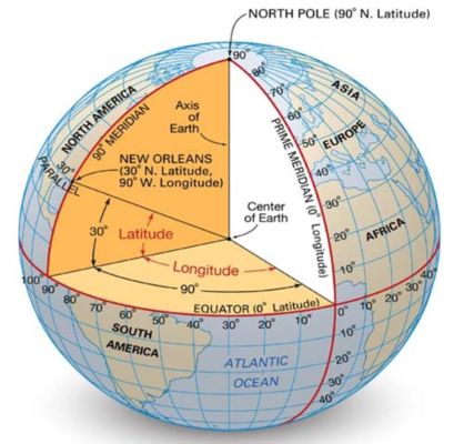
 This example is to demonstrate how decimal degree coordinates can be translated to cartesian points
import rhinoscriptsyntax as rs
import xml.etree.ElementTree as ET
import ghpythonlib.treehelpers as th
import math
R = 6371000
lat = []
lon = []
tree = ET.parse(filePath)
root = tree.getroot()
for element in root.findall('node'):
    lat.append(float(element.get('lat')))
    lon.append(float(element.get('lon')))
for element in root.findall('bounds'):
    minlat = float(element.get('minlat'))
    minlon = float(element.get('minlon'))
    maxlat = float(element.get('maxlat'))
    maxlon = float(element.get('maxlon'))
midlat = (minlat+maxlat)/2
midlon = (minlon+maxlon)/2
The Longitude distance per degree is along the x-axis remains constant around the circumference of the earth The Latitude distance per degree however, varies. It is largest by the equator and shorter towards the pole since the Latitude lines are parallel to oneanother.
(2 * pi * R) Radian Distance = 360 degrees
Y Distance per degree = (pi * R) / 180 (Where R is the radius of the earth in meters - 6371000m)
X Distance per degree = cosine(Latitude) * Y Distance per degree
ydistperdegree = (math.pi*R)/180
xdistperdegree = ((math.cos(midlat*(math.pi/180))*R)*(math.pi/180))
x_comp = []
y_comp = []
for i in lon:
    x_comp.append((i-minlon)*xdistperdegree)
for i in lat:
    y_comp.append((i-minlat)*ydistperdegree)
Points = []
for i in range(len(x_comp)):
    Points.append(rs.CreatePoint(x_comp[i],y_comp[i],0))
plane = rs.WorldXYPlane()
Boundary = rs.AddRectangle(plane,((maxlon-minlon)*xdistperdegree),((maxlat-minlat)*ydistperdegree))
